Winter Storm Warning for Two States as 15 Inches of Snow Forecast
The calendar may be showing a date in summer, but no one seems to have told the weather—with forecasters warning of a "winter storm" for some areas despite it being mid-June.
Parts of Montana and Idaho were both hit with a "winter storm warning" by the National Weather Service (NWS), which published a map on Monday showing which regions were to be affected. Up to 15 inches of snow was possible in some areas overnight, the experts said, as they warned of the dangers for drivers and possible power outages.
This comes amid a strikingly diverse weather pattern, with other parts of the country suffering from heat waves, while others are ravaged by fierce floods. Experts fear that climate change will make extreme weather events worse.
The area flagged by the NWS spanned a swathe of land encompassing both Montana and Idaho, with higher elevations predicted to suffer the worst of the storm.
In Idaho, communities as far west as Lowell and Riggins, were included on the map, which can be viewed below. (Pink shows the regions covered by the Winter Storm Warning.) Areas of Montana set to be affected include Seeley Lake, Drummond and Sula.
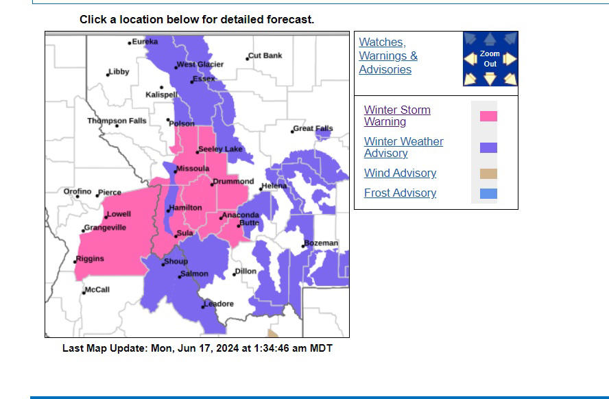
This map shows the areas, shaded in pink, that have been hit with a Winter Storm Warning this week. NWS
The NWS went into much further detail about the warning affecting Montana when it published a series of "urgent" alerts on its website on Sunday night.
Up to 6 inches of snow was forecast for the Southern Clearwater and Bitterroot Mountains, including Elk City, Red River Hot Springs, Dixie, and Lolo Pass, with up to "15 inches expected in the higher terrain including Nez Perce Pass."
Up to 15 inches of snow is also "possible for the higher terrain in the Sapphire and Bitterroot ranges including Skalkaho Pass and Lost Trail Pass," the forecasters said.
One warning, which has put into effect from midnight on Sunday to 6 a.m. Tuesday, warns of "snow accumulations 1 to 4 inches Butte to Anaconda, 2 to 5 inches at Ovando, Georgetown Lake, Macdonald Pass, and Homestake Pass. 5 to 14 inches in the higher terrain." The warning goes on to advise locals: "Backcountry travel will be very difficult. Snow on trees could cause breaking branches and power outages...If you must travel, keep an extra flashlight, food, saw, and water in your vehicle in case of an emergency. The latest road conditions for the state you are calling from can be obtained by calling 5 1 1."
Another winter storm warning was issued to warn that "I-90 East Missoula to Bearmouth, Highway 200 Bonner to Greenough, and Highway 83 Seeley Lake to Condon" should brace for "1 to 4 inches in the valleys, 6 to 10 inches in the higher elevations."
Residents should monitor their local weather reports for the most up-to-date information.
Related Articles
Start your unlimited Newsweek trial