Severe storm threat may dampen some long weekend plans in Ontario
Rain has been a part of nearly every weekend since early April, with just one exception for Father's Day weekend. So, it should come as no surprise to hear that the Canada Day long weekend will include a few rounds of showers and thunderstorms, as well.
This weekend however, will not be a washout, and sunshine is also featured in our weekend forecast. For more details on the ideal times to plan for outdoor activities, or possibly a fireworks display, see the weekend forecast set up, below.
SEE ALSO: Canada Day weekend forecast: Changeable but comfortable, with no sign of heat
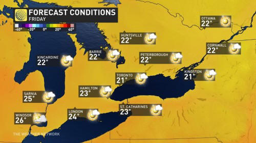
We will kick-off the long weekend with gorgeous weather during Friday afternoon and evening.
Despite abundant sunshine, temperatures will be closer to what we should typically see heading into the May long weekend. High temperatures will only reach the lower 20s across most of southern Ontario, including cottage country.
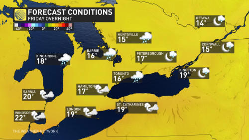
During Friday night, we will have increasing clouds, which will keep temperatures from dropping very quickly. However, we will also have an increasing threat for showers and thunderstorms during the pre-dawn hours on Saturday, especially for areas north of Toronto.
Thunderstorm chances increase through Saturday
Saturday will be a few degrees warmer and very humid. Showers and thunderstorms are in the forecast, though it won't be an all day affair. Some stronger thunderstorms are expected to be severe, and could produce powerful wind gusts and heavy rain.
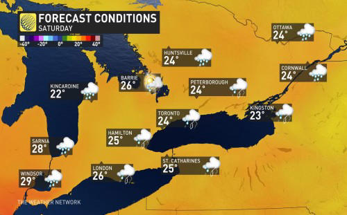
Scattered showers and thunderstorms will continue into Saturday evening. Temperatures will be quite mild overnight.
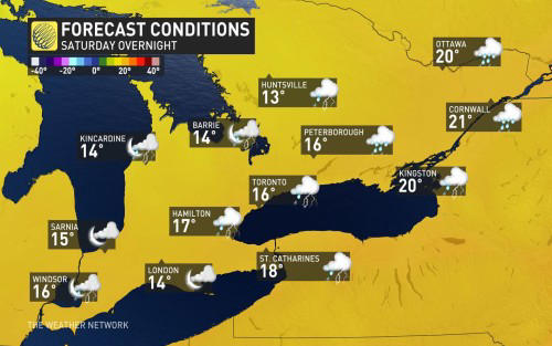
Sunday will bring a mix of sunshine and cloudy periods. We will still have a threat for passing showers, especially across cottage country, but most of the day will be dry.
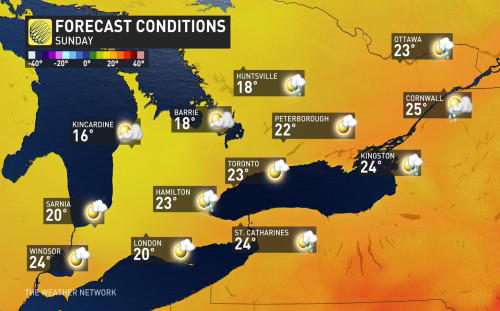
Temperatures will reach the mid 20s across most of southern Ontario, but it will be noticeably cooler across cottage country where temperatures will only reach the upper teens with a gusty northwest wind.
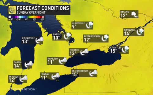
Clearing is expected Sunday evening and overnight. This will allow temperatures to fall more quickly, and parts of cottage country and Algonquin Park will even dip to the single digits.
Gorgeous Canada Day Monday, but still not feeling like July
Monday will be a gorgeous day, but it will not feel quite like early July. Despite abundant sunshine, temperatures will be several degrees cooler than seasonal – only reaching the low to mid 20s across southern Ontario.
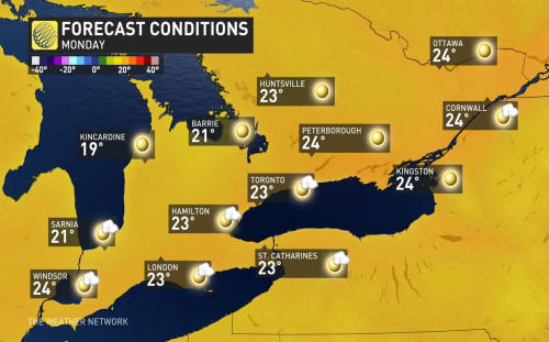
Fortunately, rain and storms will not be a concern for any fireworks displays that are planned for Canada Day.
WATCH: A Canada Day forecast that keeps everyone on their toes
Initially, we expected that a much warmer pattern would develop for the first week of July, however, the return to hot weather will be delayed.
Most of next week will be warmer than what we will see during the long weekend, but a cold front or two are expected to track across our region during the first week of July and bring a couple rounds of showers and thunderstorms and prevent consistent heat across southern Ontario.
We do expect a transition to a much warmer pattern for the second week of July and beyond.
Be sure to check back for the latest updates on your weekend weather across southern Ontario
Thumbnail image courtesy: Getty Images