An outbreak of severe thunderstorms and tornadoes is ongoing across the nation’s heartland and will continue Saturday night into early Sunday. Violent storms could unleash significant tornadoes, large hail, destructive straight-line winds and flash flooding from northern Texas into Missouri. Additional severe storms and a few tornadoes could affect areas as far north as Wisconsin and Michigan.
Severe thunderstorms began Saturday morning in western Oklahoma and northern Texas and increased to the north and east throughout the day. Dozens of tornado warnings were issued from northern Texas to northern Missouri. Several of the warnings were for confirmed “large and extremely dangerous” tornadoes that tore through areas near Devol, Okla., which is just north of the border with Texas; Chilocco, Okla., which is near the border with Kansas; Munday and Seymour in northern Texas; and Howard, Kan., which is about 60 miles east of Wichita.
The National Weather Service had received 21 reports of tornadoes through 9:30 p.m. Central time, but most had touched down over rural areas with only spotty reports of damage.
Around 9:3o p.m. Central time, radar showed almost a continuous line of thunderstorms — many of them severe — from east-central Wisconsin to near Abilene, Tex. A warning for a confirmed tornado — in effect until 10 p.m. — affected Moore and Norman in Oklahoma.
The outbreak comes less than a day after swarms of devastating twisters tore through parts of Nebraska and Iowa. It marked the third straight day of severe storms in the central states, and Sunday will probably be yet another.
On Saturday night, tornado watches stretched from parts of northern Texas through southern Wisconsin and weren’t set to expire until the pre-dawn hours Sunday. The Weather Service appeared to be particularly concerned about the overnight tornado potential from northwest Texas into northeast Oklahoma, covering roughly the area from Wichita Falls, Tex. to Tulsa. “A very moist and strongly sheared environment will support the threat for tornadoes, potentially strong, and large hail and severe gusts into the overnight,” it wrote.
Areas at risk Saturday night
Severe storms, tornadoes to continue overnight across central states
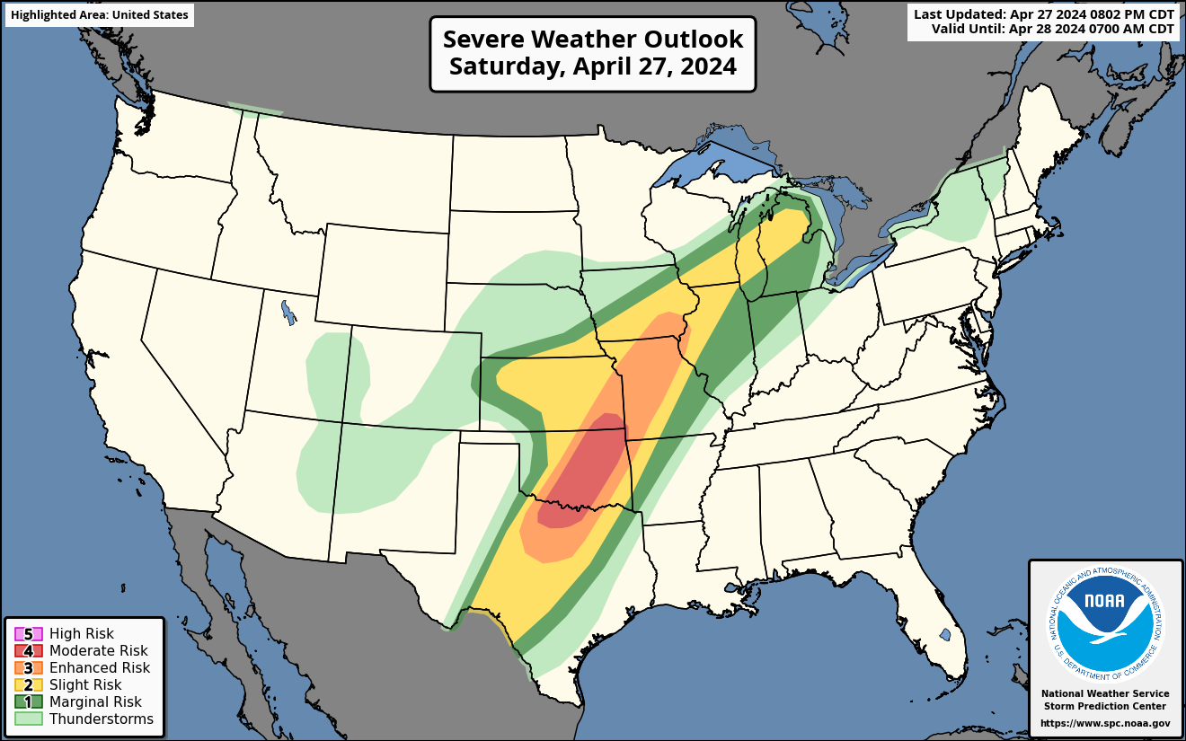
The National Weather Service Storm Prediction Center drew a red bull’s eye on outlook maps Saturday night, corresponding to a rare Level 4 out of 5 risk of severe weather from southeast Kansas through North Texas just to northwest of Dallas. Oklahoma City, Tulsa, Norman and Moore in Oklahoma; Wichita in Kansas; and Wichita Falls were included within this zone. It also included the entire Interstate 35 stretch in the state of Oklahoma, in addition to the H.E. Bailey Turnpike southwest of Oklahoma City.
Beyond that, a Level 3 enhanced risk stretched from north of Kansas City to northwest of Dallas. A broader Level 2 risk spanned from northern Michigan to northwest Kansas to the Permian Basin and Rio Grande Valley of South Texas, representing a more isolated tornado threat.
What to expect
Storms that swept through northern Texas and western Oklahoma on Saturday afternoon and evening will gradually push across the I-35 corridor, which runs north to south across the center of Oklahoma. These storms could produce tornadoes, large hail and flash flooding while progressing into eastern Oklahoma into the pre-dawn hours.
Additional storms to the north will progress through eastern Kansas and western Missouri through the evening. Some storms will also scatter across Iowa and as far north as Wisconsin and Michigan on Saturday night.
One wild card is that storms may interfere with one another and become messy. It’s unclear if that will reduce tornado risk. If nothing else, a messier structure will make it challenging to see or hear tornadoes as they approach.
Of additional note — flooding could be significant, particularly across central and eastern Oklahoma, eastern Kansas and western Missouri. That’s where thunderstorm complexes will dump copious rains, with 3 to 5 inches (or more) possible following multiple rounds of storms. The Weather Service warns of a Level 3 out of 4 risk of flash flooding from parts of northern Texas into southeast Missouri. A small Level 4 “high” risk area lies just to the east of Oklahoma City.
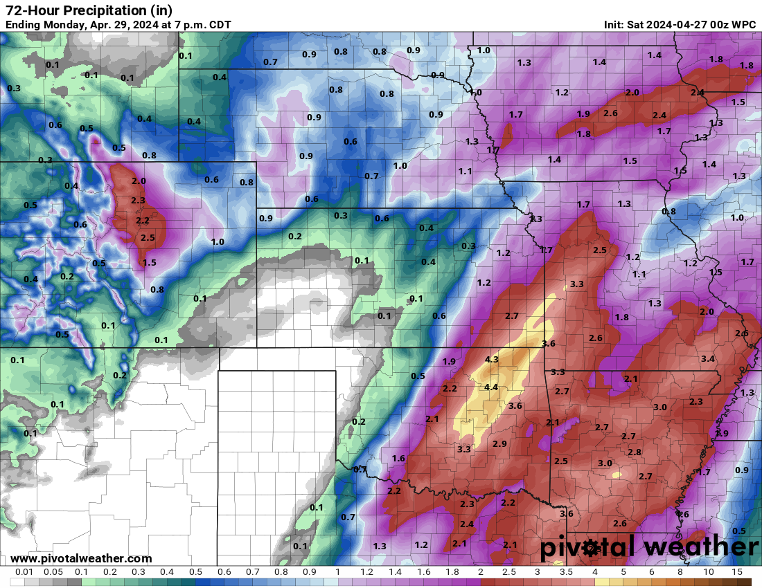
The National Weather Service’s forecast for rainfall through Monday morning. (Pivotal Weather)
Saturday storms follow violent swarm of twisters on Friday
During Friday’s outbreak, the Weather Service issued 156 severe thunderstorm warnings and 101 tornado warnings from Texas to South Dakota. It logged at least 78 reports of tornadoes, the majority in eastern Nebraska and southwestern Iowa.
One particularly intense tornado appeared to have destroyed entire neighborhoods in the greater Omaha area after crossing Interstate 80 east of Lincoln. There were no immediate reports of fatalities, but social media imagery emerged of foundations wiped bare.
Multiple “tornado emergencies” were issued by the Weather Service as storms swept from eastern Nebraska into southwest Iowa, representing the most dire tornado warnings that are a last-ditch effort to emphasize the life-or-death nature of a situation.
At first glance, radar data and damage indicators alike indicate the Omaha tornado may have been a rare “violent” tornado corresponding to EF4 strength or greater on the 0-to-5 Enhanced Fujita scale for twister intensity. Maximum winds probably approached or exceeded 170 mph, though the final determination will be made pending Weather Service storm surveys.
News Related-
Russian court extends detention of Wall Street Journal reporter Gershkovich until end of January
-
Russian court extends detention of Wall Street Journal reporter Evan Gershkovich, arrested on espionage charges
-
Israel's economy recovered from previous wars with Hamas, but this one might go longer, hit harder
-
Stock market today: Asian shares mixed ahead of US consumer confidence and price data
-
EXCLUSIVE: ‘Sister Wives' star Christine Brown says her kids' happy marriages inspired her leave Kody Brown
-
NBA fans roast Clippers for losing to Nuggets without Jokic, Murray, Gordon
-
Panthers-Senators brawl ends in 10-minute penalty for all players on ice
-
CNBC Daily Open: Is record Black Friday sales spike a false dawn?
-
Freed Israeli hostage describes deteriorating conditions while being held by Hamas
-
High stakes and glitz mark the vote in Paris for the 2030 World Expo host
-
Biden’s unworkable nursing rule will harm seniors
-
Jalen Hurts: We did what we needed to do when it mattered the most
-
LeBron James takes NBA all-time minutes lead in career-worst loss
-
Vikings' Kevin O'Connell to evaluate Josh Dobbs, path forward at QB