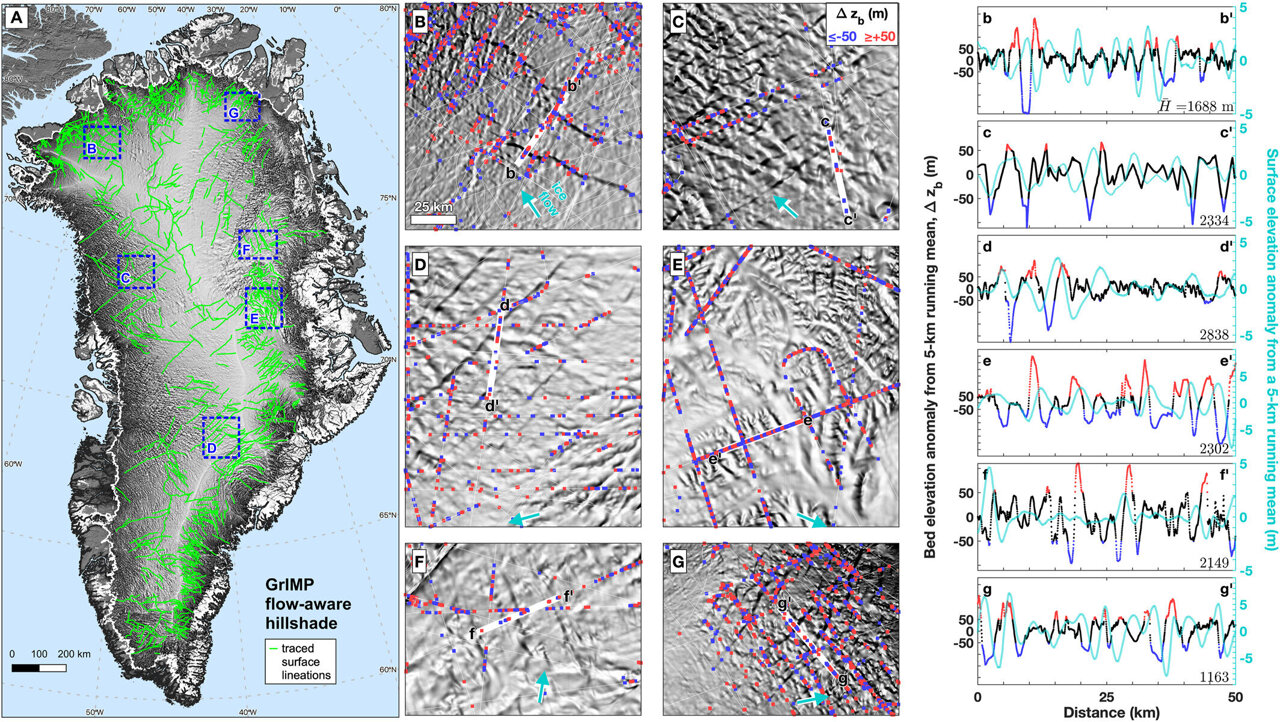
Flow-aware hillshade of the GrIS derived from the GrIMP DEM. (a) Map of the whole island with manually traced lineations. Credit: Geophysical Research Letters (2024). DOI: 10.1029/2023GL107357
A team of international scientists involving the Durham University Geography department has unveiled a new map of the geological provinces hidden beneath the Greenland Ice Sheet.
This comprehensive synthesis, published in Geophysical Research Letters, promises to advance our understanding of this critical component of the global climate system.
The new subglacial geology map provides an invaluable modernized framework for interpreting the solid Earth properties that shape the Greenland Ice Sheet’s past, present, and future behavior.
Using a wealth of geophysical data, including seismic, gravity, magnetic, and topographic surveys, the researchers have meticulously delineated the boundaries of geological provinces across the island and, crucially, beneath the ice.
Revealing a complex and heterogeneous landscape
This updated map represents a significant advancement over previous efforts, which were hampered by limited data availability.
By combining diverse geophysical datasets, the researchers have been able to map Greenland’s subsurface structure in unprecedented detail, revealing a far more complex picture than was previously known.
Notably, the team’s findings show that north of 72°N, Greenland’s geology is clearly more heterogeneous than previously thought.
There are also three distinct subglacial regions identified in central and northern Greenland whose unique geophysical signatures do not align with the island’s marginal geology, suggesting the presence of as-yet-unknown geological provinces.
Implications for understanding Greenland’s ice dynamics
The researchers also detected intriguing geophysical anomalies aligned with the onset regions of the Petermann Glacier and the Northeast Greenland Ice Stream, two of Greenland’s most dynamic outlet glaciers.
This discovery points to a potential link between subglacial geology and ice sheet dynamics, a relationship that warrants deeper investigation.
In addition, the team’s analysis of surface topography data revealed an extensive network of remarkably long, straight, and parallel subglacial valleys crossing Greenland’s interior.
These features, which remain poorly resolved in current topographic models, may hold clues about the island’s tectonic history and could provide new avenues for investigating the ice sheet’s past dynamics.
More information: Joseph A. MacGregor et al, Geologic Provinces Beneath the Greenland Ice Sheet Constrained by Geophysical Data Synthesis, Geophysical Research Letters (2024). DOI: 10.1029/2023GL107357
Provided by Durham University
This story was originally published on Phys.org. Subscribe to our newsletter for the latest sci-tech news updates.
News Related-
Russian court extends detention of Wall Street Journal reporter Gershkovich until end of January
-
Russian court extends detention of Wall Street Journal reporter Evan Gershkovich, arrested on espionage charges
-
Israel's economy recovered from previous wars with Hamas, but this one might go longer, hit harder
-
Stock market today: Asian shares mixed ahead of US consumer confidence and price data
-
EXCLUSIVE: ‘Sister Wives' star Christine Brown says her kids' happy marriages inspired her leave Kody Brown
-
NBA fans roast Clippers for losing to Nuggets without Jokic, Murray, Gordon
-
Panthers-Senators brawl ends in 10-minute penalty for all players on ice
-
CNBC Daily Open: Is record Black Friday sales spike a false dawn?
-
Freed Israeli hostage describes deteriorating conditions while being held by Hamas
-
High stakes and glitz mark the vote in Paris for the 2030 World Expo host
-
Biden’s unworkable nursing rule will harm seniors
-
Jalen Hurts: We did what we needed to do when it mattered the most
-
LeBron James takes NBA all-time minutes lead in career-worst loss
-
Vikings' Kevin O'Connell to evaluate Josh Dobbs, path forward at QB