Midwest faces 2 major winter storms in 4 days, including blizzard threat
Millions of people in the Plains and Midwest will barely have time to catch their breath after a massive winter storm affects the region into Tuesday night with heavy snow, drenching rain and high winds before an even stronger and colder storm blasts the region from Friday to Saturday. AccuWeather meteorologists warn that while the first storm will disrupt travel, the second storm could shut down travel and create dangerous conditions for those caught outdoors.
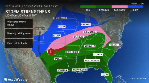
Blizzard warnings were in effect for wide open areas of the Great Plains states on Monday from the first storm that is tracking toward more heavily populated locations in the Midwest and interior Northeast. This system will eventually shift into Canada at midweek.
 Midwest faces 2 major winter storms in 4 days, including blizzard threat |
The atmosphere is making up for lost time in terms of wintry conditions and snow following a relatively mild and snowless start to the season in a large part of the central United States.
GET THE FREE ACCUWEATHER APP
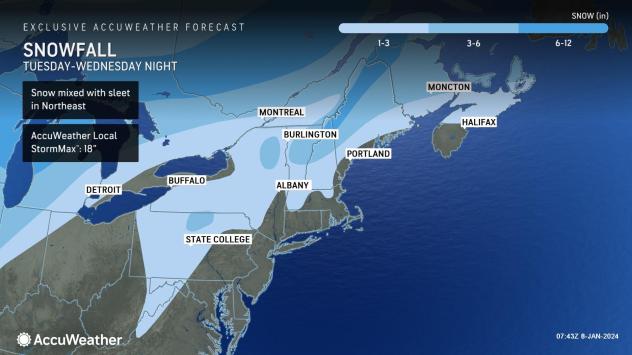
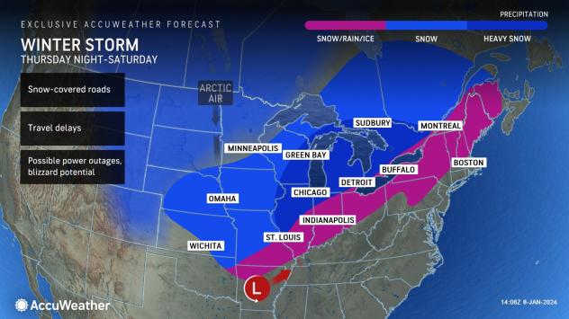
A large swath of snow and wintery mix will extend northeastward from the southern and central Plains to the Great Lakes region into Monday night. Another pocket of snow and wintry mix will break out and expand quickly over the central Appalachians and interior Northeast late Monday night and Tuesday.
 |
During Tuesday alone, wintry travel conditions will exist over 750,000 square miles. The massive storm will slice across more than 30 states with snow, ice, rain or thunderstorms, encompassing more than 2 million square miles. Widespread weather-related delays are likely for travelers.
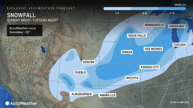
Snow of varying intensity with areas of blowing and drifting snow and even localized blizzard conditions will slowly shift from northern New Mexico and eastern Colorado to northern Michigan near and northwest of the storm track.
The storm will behave like a giant wind machine with sustained winds of 20-40 mph with gusts ranging from 40-60 mph over much of the Central and Eastern states into Tuesday night. Power outages can occur in parts of most states east of the Rockies from the storm.
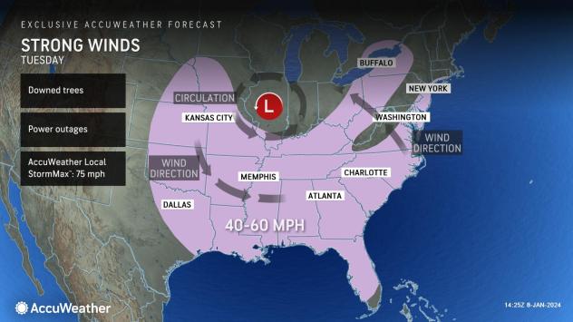 |
Hundreds of miles of Interstates 29, 35, 40, 55, 70, 80, 90 and 94 over the Plains and Upper Midwest states and Interstates 79, 80, 81, 86, 87, 89, 90 and 91 in the Northeast will experience snowy and/or icy conditions from the wintry side of the storm with increasing winds.
Major cities where AccuWeather is projecting that 3-6 inches of snow will fall into Tuesday night include Kansas City, Missouri, Grand Rapids, Michigan, and Chicago. Just to the north and west of these cities, including in part of their metro areas, 6 to 10 inches is likely to occur with locally higher amounts, including Topeka, Kansas; Des Moines, Iowa; Omaha, Nebraska; Rockford, Illinois; and Madison, Wisconsin.
 |
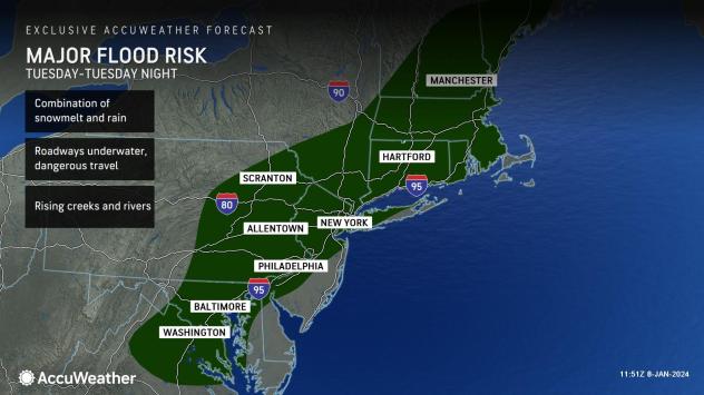
Near and southeast of the storm track, powerful warm winds and copious amounts of moisture from the storm will have a firehose effect and unleash flash flooding from the Mississippi and Ohio valleys on Monday night to the Appalachians and Atlantic Seaboard from Tuesday to Tuesday night.
The rain will not only quickly dissolve the snow and ice that falls into Tuesday but will likely wash away all of the snow that fell from the storm this past weekend.
 |
While urban and small stream flooding is inevitable, rapid surges on many of the major rivers east of the Mississippi are anticipated, with flooding of unprotected areas from the middle to late parts of the week to follow the initial flash flooding aspect of the storm.
Many roads may immediately become blocked by rushing water during flash flooding and a few days later as waters rise along the major rivers.
 |
Severe thunderstorms will erupt and tornadoes may be spawned along the Gulf Coast Monday night and the Southeast states on Tuesday from the massive storm.
Highway departments and property owners in portions of the Plains and Midwest may want to create more space for additional snow, as an even nastier blast from winter is looming from Friday to Saturday.
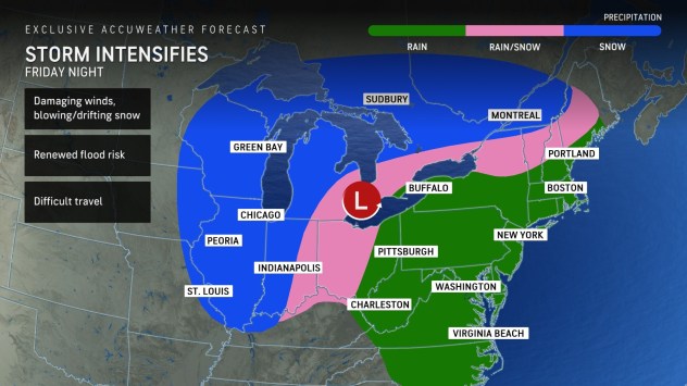
The second storm of the week is likely to become stronger and much colder than the first storm, where a more widespread zone of blizzard conditions develops with plummeting temperatures that can cause wet and slushy areas to freeze. The second storm may also track a couple of hundred miles farther to the east, which would put more areas in the Midwest at risk for more wintry aspects of the storm. This more eastward track could throw heavy snow into St. Louis, Detroit and Fort Wayne, Indiana.
Where airlines may get through the first storm with several hundred flight cancellations with ripple effects nationwide, the second storm could have many more flight cancellations and widespread implications for the weekend as airlines may still be in recovery mode following a significant amount of aircraft and crew displacement from the first storm.
 |
It is possible that parts of the Plains and Midwest may have 1-2 feet of snow on the ground in the wake of the second storm. Cities that may be hit hard by both storms include Kansas City, Chicago, Milwaukee, and Davenport, Iowa.
Blowing and drifting snow will be much more substantial and widespread during and following the second storm and could make the complete removal of snow nearly impossible. Some roads may become clogged with large drifts and stranded vehicles. Those who attempt to drive even short distances during the furious winter storm may be at risk of becoming stranded.
 |
This is the type of storm that can put those stuck outdoors at risk for hypothermia and frostbite as peak winds during the upcoming blizzard may range between 40 and 60 mph, which will push AccuWeather RealFeel® Temperatures well below zero Fahrenheit.
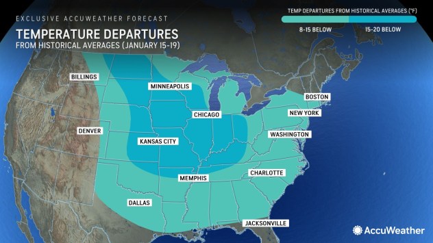
Where the power remains out in the wake of both major winter storms, people may be shivering as temperatures plummet in the wake of the storms with the coldest air of the winter so far on its way. Actual temperatures may struggle to climb past the single digits during the day and dip below zero at night in vast portions of the central and Plains and Upper Midwest this weekend as Arctic air blasts in.
 |
While both storms will bring the risk of lakeshore flooding, it is behind the second storm this weekend, where overwash will likely freeze and add to the travel difficulties. The amount of Great Lakes ice will increase substantially in the wake of the storm this weekend.
The midmonth push of Arctic air could set the stage for a mid-Atlantic snowstorm.
AccuWeather will provide updates on both storms and the scope and extent and Arctic air that follows on its various media outlets, including the AccuWeather App, website, Network and affiliated radio, TV and newspapers.
Want next-level safety, ad-free? Unlock advanced, hyperlocal severe weather alerts when you subscribe to Premium+ on the AccuWeather app. AccuWeather Alerts™ are prompted by our expert meteorologists who monitor and analyze dangerous weather risks 24/7 to keep you and your family safer.