First Alert Weather: Red Alert for heavy rain, strong wind, and possible flooding
Alerts/Watches & Warnings
A Red Alert remains in place through the afternoon hours on Monday
A Flood Watch is in effect until 5 p.m. Monday for all counties, except Nassau and Suffolk.
A High Wind Warning in place for Brooklyn, Queens, Nassau, Suffolk, and Fairfield counties from midnight through 12 p.m. Monday
A Wind Advisory is in place for Manhattan, Staten Island, and the Bronx, plus Monmouth, Ocean, Hudson, Bergen, Essex, Union, Westchester, and Dutchess counties from midnight through 12 p.m. Monday
A Coastal Flood Warning is in place for southern portions of Queens, Nassau, Suffolk, Westchester, and Fairfield counties and coastal sections of Staten Island, Bergen, Essex, Union, and Hudson counties from 10 p.m. Sunday through 6 p.m. Monday
A Coastal Flood Advisory is in place for the Bronx, Manhattan, northern Queens, Nassau and Suffolk counties, as well as coastal sections of Middlesex, Monmouth, and Ocean counties from 10 p.m. Sunday until 6 p.m. Monday.
CBS2
Timing it out and breaking it down
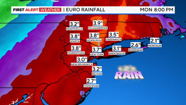
Rest of Monday: Though the heaviest rain will already be over for most areas, some lingering heavier showers are still possible through the early afternoon hours, especially across eastern Long Island. Afterwards, clearing will commence. The gusty winds will continue through the day though, gusting between 25 and 40 mph. Final rain totals will average between 2-4 inches, with higher totals in some locations. Highs will be reached early in the morning, with falling temps throughout the day.
Tuesday: A mix of sun and clouds with highs in the upper 30s to low 40s. A few snow showers are possible in the afternoon. The winds will still linger a bit though, gusting up to 25 mph at times.