Rounds of storms prompt flood, hail and tornado threats in northwestern Ontario
The week begins on a stormy note across parts of northwestern Ontario, as the rising heat and humidity fuel the threat for severe thunderstorms. Multiple weather alerts covered the region first thing Tuesday morning, as the initial round of storms brought heavy rain during the overnight hours Monday.
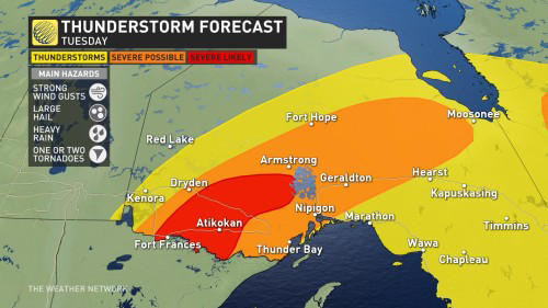
A second, and likely more severe, round of thunderstorms is expected later Tuesday afternoon and evening. This will be something you'll need to keep a close eye on.
Large hail, strong wind gusts and heavy rainfall will be the primary risks associated with any storms that form. As well, there is a low, but non-zero tornado threat, with the critical timing for severe storm development being between 4-9 p.m.
It will be important to stay on top of the weather watches and warnings in your area, as conditions can change quickly when severe weather hits.
Tuesday: Severe thunderstorms with heavy rain, hail and slight tornado threat
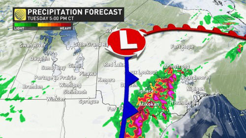
The first round of storms arrived through the overnight hours on Monday, ahead of a warm front and low pressure system. The storms produced a huge area of heavy rain, spanning nearly 400 km at the time.
A second and more potent round of thunderstorms will begin to track in through the mid-afternoon on Tuesday, as the cold front slides across the area.
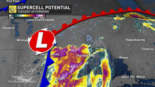
There will be strong, upper-level support, accompanied by deep moisture and the presence of high atmospheric energy.
"Areas affected by several storms or a prolonged episode of rain due to the slow movement of certain storms could receive more than 80 mm in places," warns Environment and Climate Change Canada (ECCC) in a special weather statement issued for the region, adding that the precise areas that will receive the heaviest rain remain rather uncertain.
With such heavy rainfall, there is the heightened risk of flooding.
Good wind shear will be also present, providing the final ingredient for the potential for supercell thunderstorms, which include a risk of a tornado.
For those to come to fruition, the critical timing will be between 4 and 9 p.m.
DON'T MISS: What to do if a tornado warning is issued
As such, all severe weather parameters are possible including heavy rain, a localized flood risk, large hail, strong wind gusts, and a tornado risk.
Residents in the risk areas are urged to stay weather-aware, and updated on all of the severe weather watches and warnings throughout the day.
Northern Ontario has already seen its fair share of severe weather this month. An EF-2 tornado was confirmed to have occurred on June 4, northeast of Dryden, making it the first EF-2 tornado of 2024 in Canada. An EF-1 downburst has also been confirmed in Owen Sound on June 13.
MUST SEE: How hail – of all shapes and sizes – forms, falls from sky
WATCH BELOW: Tornado safety tips
Stay tuned to The Weather Network for more weather updates across northern Ontario.