Texas in Path of Year's First Named Storm—Forecast in Maps
The first named tropical storm of the season, Alberto, is forecast to develop in the next two days.
Meteorologists at the National Hurricane Center are closely monitoring two abnormalities in the Atlantic. The first is a potential storm heading towards the Gulf Coast of Mexico with over 60 percent chance of forming a tropical storm.
The second is an incoming storm on the east coast of Florida, which currently has about a 30 percent chance of strengthening into a tropical storm. Whichever of these two systems first reaches tropical storm strength—defined as sustained winds of at least 39 mph—will be named Alberto.
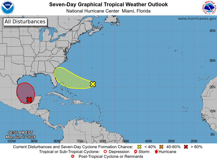
Two occurrences that could form into tropical storms
The storm building in the Gulf will have limited time over the sea but could strengthen quickly before making landfall.
"This tropical rainstorm should move over the Bay of Campeche and start to strengthen Tuesday," said AccuWeather Lead Hurricane Forecaster Alex DaSilva. "It doesn't have too much time before it eventually makes landfall in northern Mexico or possibly in extreme southern Texas Thursday morning."
How does a tropical storm form?
The hurricane season in the area has started calmly, but meteorologists predict that 2024 could be the most active on record. One indicator of impending severe storms is the temperature of the ocean. The water in the Gulf of Mexico is like a warm bath, reaching the upper 80s and expected to get even warmer.
"Very warm waters in this area of the Gulf, as well as low wind shear, will make this a conducive environment for the tropical rainstorm to strengthen," said AccuWeather Senior Meteorologist Dan Pydynowski.
Which areas will be affected the most?
The Mexican states of Tamaulipas and Nuevo León could experience the storm at its worst. Parts of southern Texas and Louisiana will be hit by heavy rainfall on Tuesday. Meteorologists warn that some areas in Texas could see up to 30 inches of rain in the hardest-hit regions. Houston already experienced heavy rain at the beginning of June, receiving the typical amount for the entire month in just a short period.
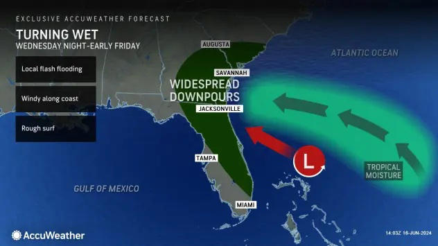
Midweek, a second storm could hit the east coast of Florida. While it will likely not reach the same strength as the one in the Gulf of Mexico, AccuWeather meteorologists still expect it to bring heavy rainfall to areas still recovering from last week's rain and floods. This new storm is expected to avoid Miami and areas south of the coastal city.
Forecasters from AccuWeather also warn that during a tropical storm, floodwaters are more dangerous than the wind, and people should avoid entering the water either on foot or in a vehicle.
Start your unlimited Newsweek trial