Severe storm risk builds Saturday for portions of the Prairies
An active pattern sweeping the centre of the country will bring a renewed risk for severe thunderstorms to portions of the Prairies during the day Saturday.
Strong to severe storms could bubble through the afternoon and evening hours across eastern Saskatchewan and western Manitoba. Keep a close eye on the radar throughout the day and have a plan to seek shelter if dangerous weather threatens your location.
DON’T MISS: How severe weather alerts are issued, and potentially save lives
Storms build Saturday afternoon
A low-pressure system pushing into Saskatchewan will serve as the spark for thunderstorms to develop through the day Saturday.

Scattered storms will develop throughout eastern Saskatchewan on Saturday afternoon, pushing into western Manitoba through the evening hours.
There remains some uncertainty with the timing and coverage of the storms. It’s likely that storms will be slow to develop during the afternoon, increasing in coverage through the evening.
Some of the thunderstorms could approach severe limits in southeastern Saskatchewan and southwestern Manitoba, including around Estevan, Brandon, and Dauphin.
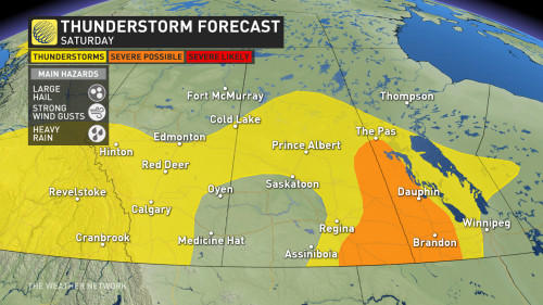
The strongest among them could produce large hail, strong wind gusts, and heavy rainfall. Remain alert for watches and warnings through the day, and stay close to safe shelter in case thunderstorms loom on the horizon.
Looking ahead, much of the Prairies can expect a chilly start to the week behind a cold front, with temperatures returning to near seasonal by the summer solstice on Thursday.
Check back for all the latest on your forecast across the Prairies.