Australia shivers through coldest night of the year
- Temperatures set to fall below July averages
- Conditions caused by 'blocking' high pressure system
- READ MORE: This is the real reason Australian homes are so cold in the winter
Millions of Australians will shiver through yet another arctic week, with temperatures set to fall below average as a cold system settles itself across much of the country.
Temperatures in southeastern Australia are expected to drop 2-6C below average, while parts of the Northern Territory, South Australia, and Western Australia could see temperatures 6-10C below average.
The chilly weather is caused by a high-pressure system that followed a cold front that swept across the region over the weekend.
Weatherzone explained while the high pressure is common after a cold front, the system will stall over Tasmania on Monday before becoming what experts term a 'blocking high' by Tuesday morning.
The large, slow-moving system is set to drive a prolonged period of frosty nights and cold days with widespread morning fog and frost patches for parts of Victoria and southern New South Wales.
The blocking high is also forecast to become so strong it even challenges Australia's all-time air pressure record.
In Queensland and northern NSW, the high pressure will bring persistent south-easterly winds to the coast, increasing the chance of showers each day.
For the remainder of northern Australia, the high to the south will increase winds, leading to warmer days.
The winds also increase the region's fire danger, given July marked the start of northern Australia's bushfire season.
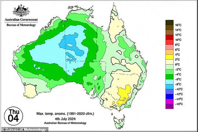
Temperatures are set to fall 2-6C below average for southeastern Australia and 6-10C below average for parts of the Northern Territory, South Australia and Western Australia
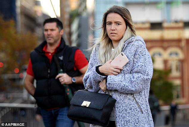
The weather system is set to drive a prolonged period of frosty nights and cold days Victoria and southern New South Wales (pictured, pedestrian in Sydney's CBD)
For parts of South Australia and Western Australia, the high pressure system along with the cold fronts will likely bring rain for longer periods than normal.
WHY IT FEELS SO COLD IN AUSTRALIA RIGHT NOW
Australia just shivered through its coldest night of the year to date with a low of –9.6C at Thredbo Top Station.
Sydney dipped to 6.4C early on Monday morning, which was its second-coldest night of the year to date, but the remarkable figure was the apparent or 'feels like' temp which fell to –0.1C at 6 am due to the wind chill.
Canberra had a low of –5.4C, its third-coldest night of the year to date.
Melbourne didn't have a particularly cold night with a low of 6.8C but we mention Melbourne here because it is set for a string of extremely chilly nights, with a low of just 1C expected on Wednesday morning for the city, with subzero temps in some outer suburbs.
Cold days also lie ahead for Melbourne, with tops of just 12 or 13 degrees on the cards all the way through till Saturday.
SOURCE: WeatherZone.com.au
Brisbane
It is a wet start to the week for residents in Brisbane.
Up to 20mm of rain is forecast for Tuesday and 10mm on Wednesday before easing towards the end of the week.
Possible showers are forecast from Thursday before increasing over the weekend, with up to 4mm set to fall on Sunday.
Maximum temperatures will remain between the high teens to low 20s for the week, while minimum temperatures hover around the low to mid teens.
Sydney
Showers are forecast for the week, with the heaviest falls of up to 15mm set for Tuesday.
Between 7 to 9mm of rain is expected to fall each day from Wednesday through to Sunday.
Maximum temperatures will remain around the mid to high teens, while minimum temperatures will settle between 10 and 11C.
Canberra
Residents in Canberra will have a cold but relatively dry week, with partly cloudy weather forecast well into the weekend.
Morning frost is expected on Tuesday and Wednesday, while the slight chance of a shower is forecast from Thursday and through to the weekend.
The mercury will fall to an icy -2C on Tuesday and 0C on Wednesday, with minimum temperatures reaching a high of 3C.
Maximum temperatures for the week will remain around the low to mid teens.
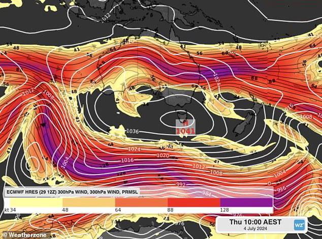
Weatherzone explained while the high pressure is common after a cold front, the system will stall over Tasmania before become what experts term a 'blocking high'. The system is also set to challenge Australia's all-time air pressure record (pictured)
For parts of South Australia and Western Australia, the high pressure system will likely bring rain for longer periods than normal (pictured, people walking on Henley beach, Adelaide)
Melbourne
A cold and dry week is forecast for Melbourne, with partly cloudy days set for the week ahead.
Maximum temperatures are expected to range between 12C and 14C.
The mercury will drop to a chilly 1C on Wednesday, with minimum temperatures settling around 2C to 3C for the rest of the week.
The blocking high pressure system will also bring frost to some areas of the city and the chance of morning fog for most of the week.
Hobart
Aussies in Hobart will enjoy a cold but mostly sunny week as temperatures reach a maximum of 11C to 12C, while minimum temperatures hover between 2C and 3C.
Meanwhile, in Launceston, temperatures are forecast to fall below zero degrees for the next seven consecutive mornings.
Adelaide
Cold and dry weather is forecast for the start of the week in Adelaide before the chance of showers develops from Thursday through to Sunday.
Maximum temperatures will remain around the mid teens.
Tuesday and Wednesday will see minimum temperatures of 4C, before rising to a minimum of 10C on Sunday.
Up to 10mm of rain is forecast to fall across three days from Friday and over the weekend.
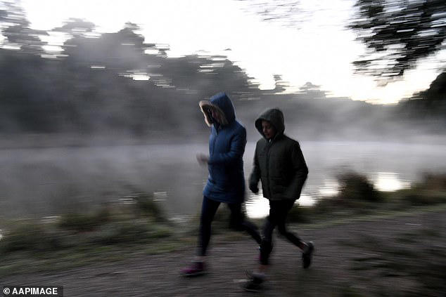
Pictured, two early walkers brave the cold weather at Birdsland reserve in Belgrave South, east of Melbourne
Perth
Mostly sunny weather is forecast for Perth this week.
The mercury will fall as low as 6C on Wednesday, while maximum temperatures will reach the high teens across the week.
Showers and up to 8mm of rain is expected on Tuesday before clearing and then returning on the weekend, with up to 15mm of rain on Sunday.
Darwin
Meanwhile, residents in Darwin will escape the cold weather with sunny conditions and temperatures remaining in the low 30s well into the weekend.
Minimum conditions will see some mornings drop to 17C and 19C.
FIVE-DAY FORECAST FOR CAPITAL CITIES
ADELAIDE
Monday: Max 14C, partly cloudy.
Tuesday: Min 4C Max 14C, partly cloudy. Chance of morning frost.
Wednesday: Min 4C Max 14C, mostly sunny. Patches of morning.
Thursday: Min 6C Max 15C, possible shower. 0-1mm of rain.
Friday: Min 8C Max 16C, shower or two. 0-3mm of rain.
MELBOURNE
Monday: Max 12C, mostly cloudy.
Tuesday: Min 4C Max 12C, cloud clearing. Patches of morning frost and fog.
Wednesday: Min 1C Max 13C, mostly sunny. Areas of frost and chance of morning fog.
Thursday: Min 2C Max 13C, partly cloudy. Areas of frost and chance of morning fog.
Friday: Min 3C Max 13C, partly cloudy. Slight chance of a shower.
SYDNEY
Monday: Max 15C, showers. 0-6mm of rain. to 1-4mm of rain.
Tuesday: Min 10C Max 16C, rain. 1-15mm of rain.
Wednesday: Min 11C Max 17C, showers. 1-9mm of rain.
Thursday: Min 11C Max 17C, showers. 1-8mm of rain.
Friday: Min 12C Max 18C, showers. 1-8mm of rain.
DARWIN
Monday: Max 33C, sunny.
Tuesday: Min 22C Max 33C, sunny.
Wednesday: Min 21C Max 32C, sunny.
Thursday: Min 19C Max 31C, sunny.
Friday: Min 17C Max 31C, sunny.
Source: Bureau of Meteorology
CANBERRA
Monday: Max 12C, partly cloudy.
Tuesday: Min -2C Max 12C, partly cloudy. Morning frost.
Wednesday: Min 0C Max 13C, partly cloudy. Morning frost.
Thursday: Min 1C Max 13C, slight chance of showers. 0-1mm of rain.
Friday: Min 2C Max 14C, slight chance of showers. 0-1mm of rain.
HOBART
Monday: Max 11C, mostly sunny.
Tuesday: Min 3C Max 11C, partly cloudy.
Wednesday: Min 3C Max 11C, sunny.
Thursday: Min 2C Max 11C, mostly sunny. Chance of morning frost.
Friday: Min 2C Max 12C, mostly sunny. Patches of morning frost.
BRISBANE
Monday: Max 20C, showers. 1-4mm of rain. Chance of thunderstorm. Light winds.
Tuesday: Min 13C Max 17C, rain. 4-20mm of rain. Light winds.
Wednesday: Min 13C Max 19C, showers. 0- 9mm of rain.
Thursday: Min 12C Max 21C, possible showers. 0-1mm of rain.
Friday: Min 12C Max 22C, possible showers. 0-1mm of rain.
PERTH
Monday: Max 20C, sunny.
Tuesday: Min 11C Max 19C, showers. 2-8mm of rain.
Wednesday: Min 6C Max 18C, sunny.
Thursday: Min 7C Max 19C, mostly sunny.
Friday: Min 7C Max 18C, sunny.
Read more