Rain bomb to strike Australia this weekend: What you need to know
Heavy rain, thunderstorms and flash flooding could impact large swathes of Australia this weekend with more rain expected after a week of wet weather.
A high pressure system centred just south the country is drawing in moisture from the atmosphere which will turn to rain as it meets a pool of upper-level cold air over the next few days.
NSW and Victoria are in for a soaking, while southern WA, eastern SA and southern Queensland will also see significant falls.
The northern half of the country will see some showers but remain mostly dry while Tasmania will see cool and cloudy conditions but avoid significant rainfall.
The rain in the eastern half of the country will move from SA towards the coast, hitting Melbourne on Friday and Sydney by late Friday night.

South-east Australia is in for a soaking over the weekend as this cumulative rainfall map for the seven days until Tuesday shows
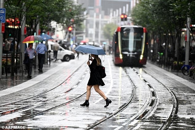
Sydneysiders should take a umbrella with them if venturing out this weekend and those further south in Illawarra and the South Coast should watch for flood warnings
Already saturated catchments in NSW and Victoria could quickly flood, particularly in the Illawarra and South Coast regions of NSW where weekend rainfall totals could exceed 150mm.
The Bureau of Meteorology’s Sarah Scully said the upper-level trough will combine with a coastal trough over NSW on Saturday and ‘ramp up’ the rainfall.
‘Moderate to heavy rainfall is expected in the southern half of NSW,’ Ms Scully said.
‘We’re expecting to issue a severe weather warning as grounds are really wet through eastern parts of NSW due to recent rainfall.
‘Inland NSW the rainfall totals look to be more than 50mm over the weekend, some places even reaching 100mm.’
The Bureau also has a hazardous surf warning in place for Saturday for the Macquarie coast, Hunter coast, Sydney coast and Illawarra coast.
Canberra, Brisbane and Cairns will see some showers over the weekend and mild temperatures with Canberra dipping into the single figures overnight.
Darwin and Adelaide will be in for a fine weekend with tops in Adelaide in the low 20s and Darwin in the low 30s.
The rain will ease by Tuesday over most of the country.
The second half of next week is forecast to be fine though cool autumn weather.
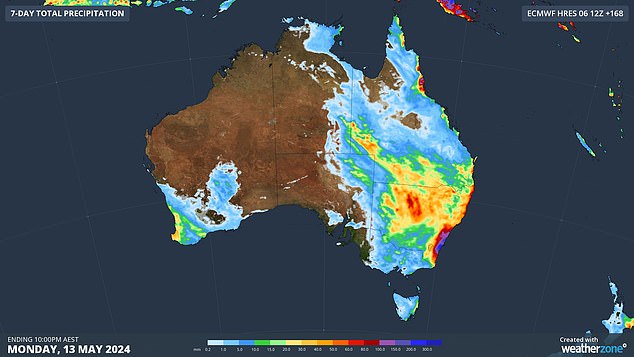
The rain will be focused on the eastern and south-west parts of the country with the central and northern regions escaping most of the rain
Sea surface temperatures remain the warmest on record globally since April 2023 which is affecting the historical modelling for declaring weather events such as El Nino or La Nina.
The bureau said sea surface temperatures continue to increase, with temperatures in February, March and April setting records.
The Pacific Ocean will likely return to a neutral model (known as an El Nino Southern Oscillation or ENSO) – neither El Nino or La Nina – by June.
There are also predictions a La Nina will return by late winter but forecasts will not be firm enough to declare until after May.
‘El Nino and La Nina predictions made in early autumn tend to have lower accuracy than predictions made at other times of the year,’ the bureau said.
‘As the current global ocean conditions have not been observed before, inferences of how ENSO may develop in 2024 that are based on past events may not be reliable.’
La Nina conditions typically lend to higher rainfall totals and cooler average day time temperatures.
WEEKEND WEATHER IN YOUR CITY
SYDNEY
Friday Rain increasing. Max 22
Saturday Rain. Min 14 Max 19
Sunday Showers. Min 14 Max 21
Monday Shower or two. Min 14 Max 23
BRISBANE
Friday Partly cloudy. Max 24
Saturday Shower or two. Min 15 Max 24
Sunday Shower or two. Min 17 Max 25
Monday Sunny. Min 15 Max 27
ADELAIDE
Friday Mostly sunny. Max 22
Saturday Partly cloudy. Min 10 Max 21
Sunday Partly cloudy. Min 9 Max 21
Monday Partly cloudy. Min 9 Max 20
MELBOURNE
Friday Rain at times, easing. Max 18
Saturday Partly cloudy. Min 11 Max 20
Sunday Cloud clearing. Min 9 Max 18
Monday Partly cloudy. Min 11 Max 19
CAIRNS
Friday Showers. Max 28
Saturday Showers. Min 21 Max 28
Sunday Shower or two. Min 21 Max 29
Monday Shower or two. Min 21 Max 29
PERTH
Friday Showers. Possible storm. Max 25
Saturday Partly cloudy. Min 15 Max 24
Sunday Partly cloudy. Min 15 Max 26
Monday Partly cloudy. Min 16 Max 27
HOBART
Friday Shower or two. Max 15
Saturday Partly cloudy. Min 11 Max 17
Sunday Partly cloudy. Min 8 Max 18
Monday Possible shower.Min 9 Max 17
CANBERRA
Friday Rain increasing. Max 17
Saturday Rain. Min 8 Max 15
Sunday Shower or two. Min 7 Max 17
Monday Mostly sunny. Min 5 Max 20
DARWIN
Friday Possible morning shower. Max 34
Saturday Sunny. Min 25 Max 35
Sunday Sunny. Min 24 Max 34
Monday Sunny. Min 24 Max 34
Read more