A Pasig River Esplanade Walking Tour with Paulo Alcazaren
(SPOT.ph) It is Paulo Alcazaren’s only available day for an interview and it happens to be on a very busy weekend. We are to meet at the Pasig River Esplanade—that 500 meter sliver of open space behind the Post Office in Manila that he and architect William Ti of WTA have been enlisted to help design and plan. Apparently the roads leading up to the esplanade have been closed to vehicles today so we decide to meet at the parking area by the Metropolitan Theater instead.
“This used to be a road for vehicles,” Paulo mentions as we stroll along the pedestrian walkway in between Arroceros Forest Park and the storied theater. He recalls suggesting turning this area into a more pedestrian friendly civic space many years ago. If there is one thing you need to know about Alcazaren it is that he’s a staunch advocate of public, open spaces for people. He’s the principal at PGAA Creative Design and was the designer of the Iloilo Esplanade. Previous to this he was also involved in developing the esplanade on both banks of the Singapore river.
Paulo PHOTO BY Jar Concengco
Paulo has agreed to give me a tour of the esplanade and its surrounding environs. The place has become a major tourist draw since it opened in January this year, and while it does offer a stunning vista of Manila and a great backdrop for pictures, visitors could make the most of their pasyal if they’re going with someone knowledgable about the landmarks connected to it.
Landmarks Connected to the Pasig River Esplanade
He points to the Metropolitan Theater and shares little tidbits about its Art Deco architecture as we pass it. “Notice the columns have an art deco form but they are adapted to the tropical vernacular by the addition of capiz?”
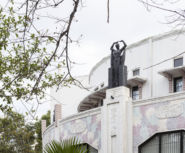
The Metropolitan Theater. PHOTO BY Jar Concengco
Next, he points across the overlapping streets full of vehicles. “There used to be an ice plant across over there,” he says. “Tunnels from the ice plant connected to the theater to bring in cool air, making it one of the first air-conditioned buildings in the Philippines.”
We take the underpass to cross Padre Burgos and get to Liwasang Bonifacio. Here, we notice a couple of foreign tourists walking across the broken and rocky pathways of the park. “See those foreign tourists? On the map kasi, if you stay in one of the hotels and you look at the physical distance to things, in an other city, you can walk in comfort without having to go through all this blight,” Alcazaren tells me. “Here, our tourism planners don’t do that because they’re always in their SUVs and air-conditioned cars. They never think about the actual user experience so you have things like this. These tourists won’t come back.”
Anyone who has ever walked through Liwasang Bonifacio knows how poorly maintained the park is, and it looks even more dreary with the Post Office’s blackened facade caused by the massive fire May of last year. “This is the Post Office. It’s neo-classic. You’ve been to Washington D.C.? The National Mall?” he asks me.
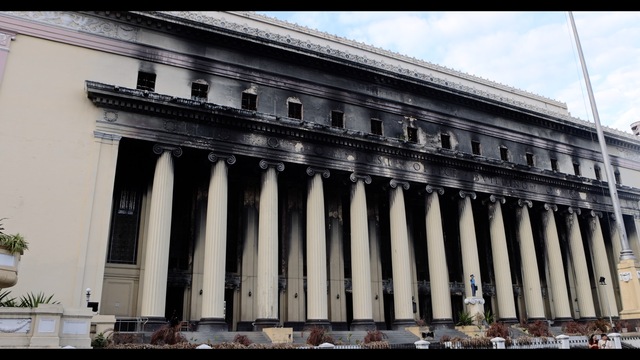
The Manila Post Office PHOTO BY Jar Concengco
“The Rizal Park was our National Mall. In 1898, the National Mall’s redesign was under the leadership of a guy named Daniel Burnham – Chicago-based planner and architect. He worked with a number of people to do that plan. Burnham was asked to come here in 1904 and he did a masterplan of Manila. If you look in the air or look at Google Maps, you will see that Rizal Park is the same width as the National Mall in D.C. The Washington monument is the Rizal monument. Instead of the Potomac we have the Manila Bay.”
Burnham originally designed Rizal Park to have six buildings to form a central group around a Capitol – three of which were never built, including the Capitol. Burnham intentionally wanted the Post Office by the Pasig River.
Why a post office by the river?
“Why a post office by the river? Because all the mail were carried by ships and boats at that time. Airplanes only came in the late 30s. All of the post were brought here and offloaded into the lighters behind the post office where the esplanade is. So historically, you have to tell the story of the Post Office and why it’s beside the water and why it’s so important to understand that story of communication,” Alcazaren says.
Ferries used to take people from Manila Bay all the way down to a town in Laguna called Bay (which is pronounced ba-ee). “The town of Bay is still there. That’s the end point and you connect to the hinterlands. The produce from Laguna was loaded in the towns around the lake and were brought here.”
Alcazaren then goes on to tell me Liwasang Bonifacio used to be called Plaza Lawton, named after the American general Henry Lawton. “Lawton’s claim to fame before coming over to the Philippines was capturing the Indian chief Geronimo.” In 1899, he died in the Battle of San Mateo by a Filipino sharpshooter named Licero Geronimo, the namesake of the chief he captured back in America.
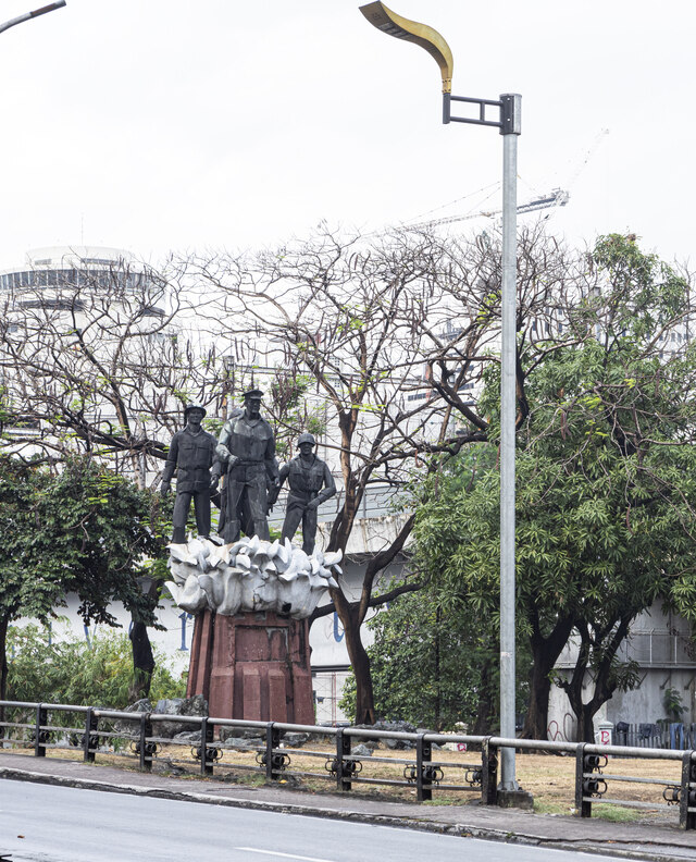
“This is our MacArthur Park.” PHOTO BY Jar Concengco
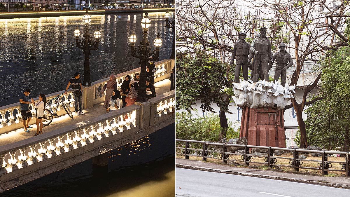
Before heading into the esplanade, we walk towards the other side where the MacArthur Bridge is and he points out a small inaccessible park. “Los Angeles has a MacArthur Park. This is our MacArthur Park. Nobody even knows it’s here.”
The small monument has MacArthur and two soldiers on what seems to be waves of water. Alcarazen says it was built in the 1970s during the same time as the building of the LRT.
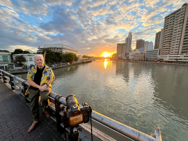
We walk up the MacArthur Bridge as the sun is about to set. The esplanade can be seen crowded with people who want to see Manila’s first large park built in the last 50 years. He points at the Jones Bridge. “The original Jones bridge was heavy on ornamentation. The peg that Burnham used was the Pont Alexandre III bridge in Paris. It replaced the old Puente de España (Bridge of Spain).
Until the American colonial period which is 1898, there were only two bridges crossing the Pasig. That was the main bridge that connected the south bank with the north bank, which is Intramuros with Chinatown. “That was the essential bridge of commerce,” Alcazaren continues. “The second bridge is an art deco bridge in Arroceros completed in the late 30s. It connected Arroceros with Quiapo and Santa Cruz. Arroceros is called arroceros because arroz is rice. So the rice warehouses were there. And that bridge connected to the Quinta market. The markets of course were by the river.”
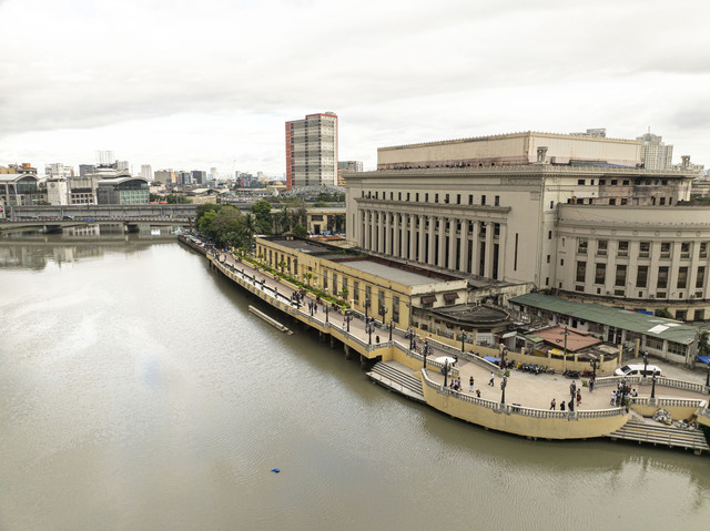
A view of the stately Post Office building fronted by the Pasig River Esplanade. PHOTO BY Jar Concengco
This new project that Alcazaren is working on with the inter-agency council for the Pasig River Urban Development aims to address the concerns and goals of reviving the river. Historically, the Pasig river has been the lifeline of Manila. It’s how people communicated before, how people got their food, and how people traveled.
“So it’s important to reconnect because the Pasig offers an opportunity for a more efficient transportation. The Pasig river has always been a central spine in the history of Manila – economically, socially, politically even,” Alcazaren says.
As we witness Manila’s famous sunset among the throngs of people on the new esplanade, it is evident how people yearn for public, open spaces in the city. “We didn’t expect this would be so popular because this is only 500 meters – effectively only one percent of the total length that we aim to build in the next three years.”