Map Shows Where Californians Advised to Wear Masks Outside
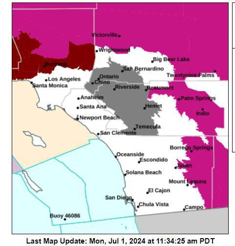
The updated map uses color-coding to indicate air quality levels across the region, with areas in orange and red signaling where N95 or P100 respirator masks are recommended for outdoor activities. As of Monday morning, large swaths of San Bernardino and Riverside counties were highlighted, including major cities like Riverside, San Bernardino, Ontario, and Corona. NWS
As wildfires continue to rage across parts of Southern California, air quality concerns have prompted officials to issue warnings and recommendations for residents in affected areas going into the Fourth of July week.
A new map released by the National Weather Service (NWS) and the South Coast Air Quality Management District (AQMD) now shows precisely where Californians are being advised to wear masks outdoors due to elevated levels of fine particle pollution.
The updated hourly map uses color-coding to indicate air quality levels across the region, with areas in orange and red signaling where N95 or P100 respirator masks are recommended for outdoor activities. As of Monday morning, large swaths of San Bernardino and Riverside counties were highlighted, including major cities like Riverside, San Bernardino, Ontario, and Corona.
The air quality alert, initially issued Sunday evening, is expected to remain in effect until at least 3 PM Monday. However, officials warn that the situation remains fluid and could extend depending on fire behavior and weather conditions.
Fine particle pollution, also known as PM2.5, poses significant health risks, especially for vulnerable populations. These microscopic particles can penetrate deep into the lungs and even enter the bloodstream, potentially causing or exacerbating respiratory and cardiovascular issues.
The South Coast AQMD has issued a series of recommendations for residents in affected areas:
- Stay indoors with windows and doors closed when possible.
- Avoid vigorous physical activity, both indoors and outdoors.
- Run air conditioners and air purifiers if available.
- Avoid using whole house fans or swamp coolers that bring in outside air.
- Refrain from burning wood in fireplaces or fire pits.
- Minimize sources of indoor air pollution such as candles, incense, and frying foods.
- Wear a properly fitted N95 or P100 respirator mask if outdoor activities are necessary.
- Limit the use of gasoline-powered lawn and garden equipment.
The California Department of Public Health has also stepped-up efforts to distribute N95 masks to communities in need.
Adding to the air quality concerns, the National Weather Service in Los Angeles (NWS) has issued an "extreme risk" warning for high temperatures this week. The heat index is predicted to peak between Thursday and Sunday, with deserts potentially reaching up to 116 degrees Fahrenheit. Excessive heat warnings cover multiple parts of the state, including Sacramento Valley, Coachella Valley, and San Diego County Deserts.
In light of these conditions, forecasters are urging residents to exercise caution during Independence Day celebrations. "Be extra careful with any potential fire ignition sources, including 4th of July fireworks," the NWS warned. The combination of extreme heat and poor air quality creates a perfect storm for potential health hazards.
The NWS advises residents to stay hydrated, limit outdoor activities during the hottest times of the day, check on elderly neighbors, and ensure pets are not left in vehicles.
The South Coast AQMD encourages residents to stay informed about local air quality conditions by visiting their website or downloading their mobile app. The agency also maintains a hotline for air quality complaints and questions.
As firefighters continue to battle blazes across the state and communities prepare for Fourth of July celebrations, California's Office of Emergency Services reminds residents to stay prepared, heed all evacuation orders, and take necessary precautions against both poor air quality and extreme heat.
Start your unlimited Newsweek trial