Snow Map Shows States Where Snow Depth Will Be Highest
A map of estimated new snow depths across the contiguous U.S. shows multiple winter storms will leave much of America carpeted in at least an inch of snow by Sunday morning.
The model, produced by the National Weather Service (NWS) on Thursday, suggests that, as of 6 a.m. ET on Sunday, more than 32 inches will have fallen across the Cascades mountain range in Oregon, as well as parts of Idaho, northern Nevada and Utah.
The Great Lakes region is also expected to see high snow accumulations, with as much as 20 inches in parts of Michigan.
A storm that brought blizzard conditions to western central states earlier in the week has been shifting northeastward toward the central Midwest and Great Lakes, promising to bring more heavy snow and whiteout conditions to parts of northern states.
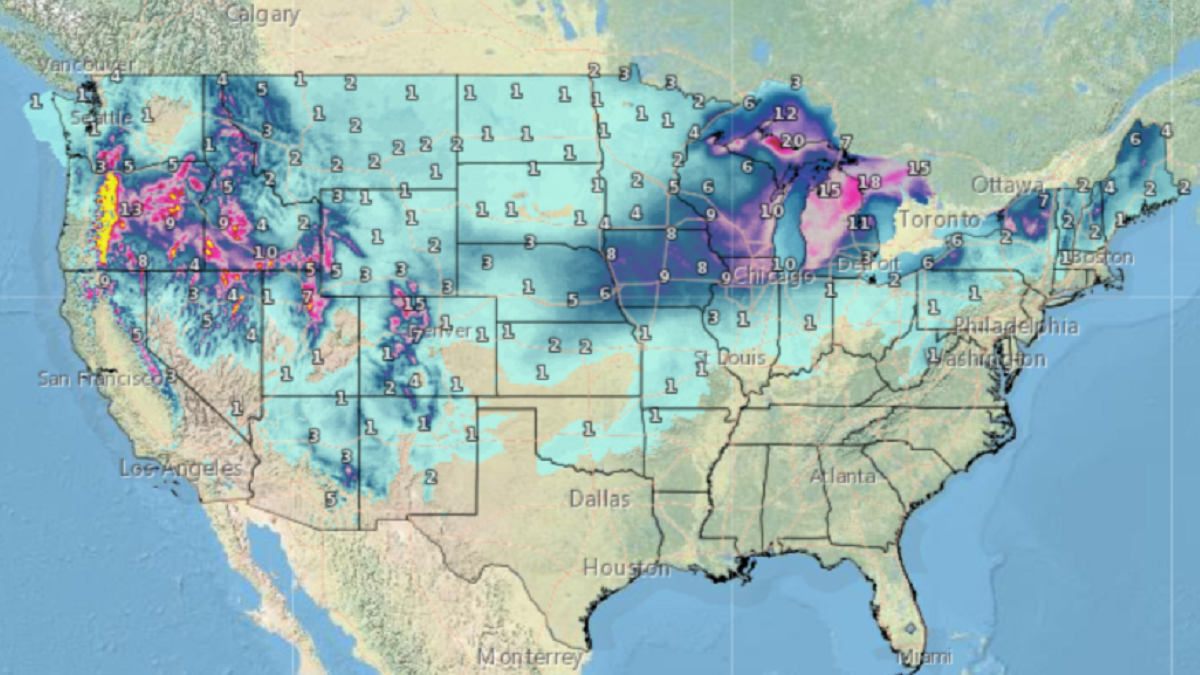
A map of the contiguous U.S., created on January 11, 2024, showing expected snow depths as of 6 a.m. on January 14. Light blue denotes up to an inch, with yellow indicating accumulations in excess of 32 inches. NWS
In a forecast on Thursday morning, the NWS said that starting Saturday, “a major winter storm with blizzard conditions is expected from eastern Nebraska to central Michigan with widespread 6-12 inch snowfall totals within this corridor of the Midwest, with potentially over a foot of snow across northern Lower Michigan.”
At the same time, northwestern states faced heavy precipitation from two “powerful” atmospheric river storms on Monday and Tuesday, bringing rare blizzard warnings to the areas surrounding Seattle.
While the worst of the winter weather has abated for the moment, heavy snow is set to continue across the Cascades of Washington and Oregon, as another storm works its way inland on Saturday. The NWS predicts up to 4 feet of snow could accumulate at higher elevations, with wind gusts as high as 50 mph.
Parts of northern Idaho and western Montana continue to be affected by the storms and travel could be “very difficult to impossible,” with the danger of frostbite on exposed skin in as little as five minutes.
The NWS attributed the “brutal” temperatures for the region to a colder, Arctic air mass moving south and east in the wake of recent storms, which it expects to persist “well beyond the end of the week.”
Snow from a storm that developed over the central and southern Plains earlier in the week is expected remain as high temperatures are likely to stay below 20 degrees Fahrenheit. Between 1 and 3 inches of snow is expected across the region, with locally higher amounts.
While the East Coast faced areas of flooding, and the Southeast could see tornado-bearing severe thunderstorms, the mid-Atlantic is predicted to see lower rainfall totals than the NWS previously anticipated. However, up to 2 inches of rain “could cause some instances of flooding across already saturated grounds,” the agency warned.
Northern New England is expected to see up to 7 inches of snow.
Related Articles
Start your unlimited Newsweek trial